In real estate, speed and certainty defines success.
Yet, brokers, builders, and consultants often face the challenge of
ambiguous parcel boundaries, unreliable land records, and time-consuming verification
processes.
The result: delayed deals, legal disputes, and missed opportunities.
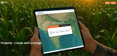
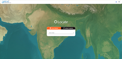
ADL’s REAL platform provides the only nationwide, survey-verified land intelligence
system built for India’s real estate ecosystem.
Rather than just guiding you to the “best” parcel, REAL helps you eliminate what is unsuitable
based on your purpose or intent — ensuring only viable, verified options remain for
consideration.
Explore these quick videos to get started and master the platform.
Step-by-step guide to creating your account and getting started.
Learn how to locate your property and leverage the platform features.
Explore these quick videos to get started and master the platform.
Challenge Area | Before REAL | with REAL Platform |
---|---|---|
Parcel Verification | Manual checks with fragmented, outdated records. High chance of boundary disputes. | Instant access to survey-verified cadastral boundaries across India. |
Time to Shortlist | Weeks spent screening land parcels through field visits and multiple local sources | Unsuitable parcels eliminated upfront, leaving only viable options. Saves weeks in deal cycle. |
Data Consistency | Varies by state/district. Different formats, incomplete records, limited transparency. | Uniform, structured data across states and regions on a single platform |
On-Ground Validation | Heavy reliance on site visits, local brokers, and manual sketches. | Satellite overlays & GIS verification confirm on-ground reality remotely. |
Risk Exposure | High — due to misrepresentation, legal disputes, or hidden encroachments. | Lower risk with authentic, validated datasets and transparent maps. |
Client Confidence | Limited — clients rely mostly on trust and local broker assurances. | Enhanced trust — clients see validated boundaries, clear maps, and digital proof. |
Survey Boundaries on Satellite Maps
Geographical Area & Landmarks Roads, Water Bodies, City Centres
Municipal & Administrative Boundaries
Property Access & Connectivity
Land Profile
Elevation, Contours
Construction Feasibility Proximity to Airports, Roads
Agricultural Suitability Growth Potential, Soil Moisture
Current & Past Land Use Agriculture, Development